What happened during Storm Franklin?
Storm Franklin brought persistent heavy rain and significant fluvial flooding to many parts of the UK resulting in over 400 Flood Alerts and Flood Warnings being issued by the Environment Agency (Gov.uk, 2022).
Severe Flood Warnings were issued for the River Mersey in Greater Manchester, and for the River Severn in Shropshire and in Worcester, suggesting flooding posed a danger to life (Gov.uk, 2022). In Manchester, around 70 homes were evacuated due to impending floodwater (Brown et al., 2022). Properties in Ironbridge, Leeds, and Worcester were also evacuated (Brown et al., 2022).
Flood Foresight
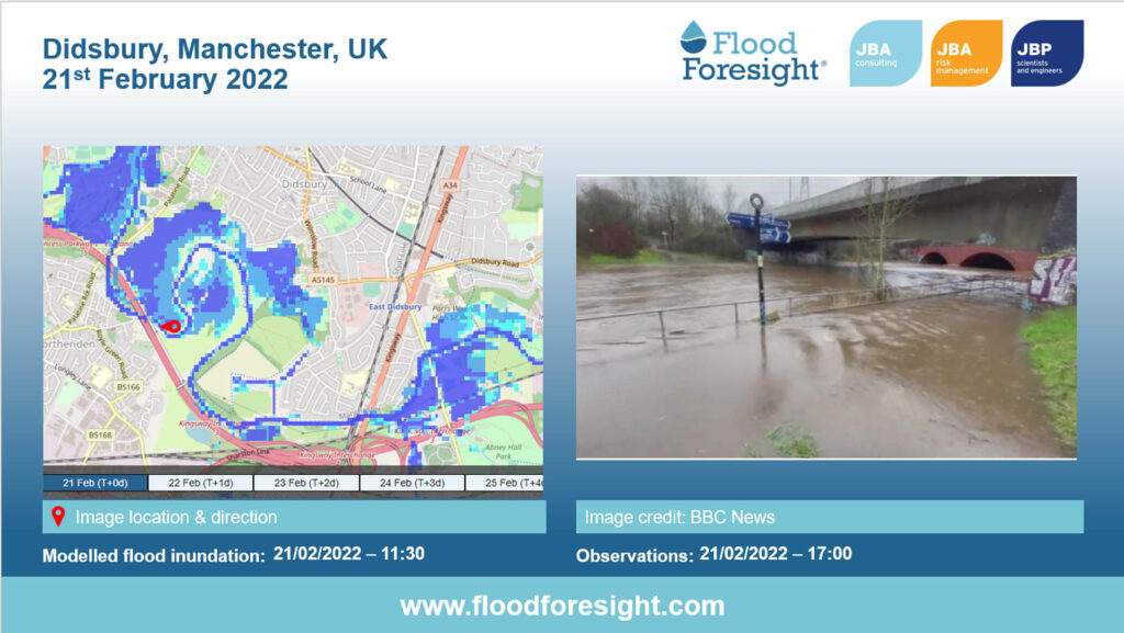
Our Flood Foresight fluvial forecasting system forecasted numerous instances of flooding throughout the UK between 20 and 26 February 2022, with a particular focus on the North, West, and Midlands. Floods were forecast as early as 14 February in areas such as the Lake District, Manchester, and East Yorkshire. For the River Mersey at Didsbury in Manchester, the system forecasted flooding seven days in advance of the actual flood events.
Our Flood Foresight flood monitoring module provides real-time flood depth footprints driven by river gauges with three hourly updates. This system modelled the flood inundation footprint for the River Mersey at Didsbury, Manchester on 21 February. The image below shows the Flood Foresight flood inundation map and a photograph of actual events on the ground.
In Ironbridge, Shropshire, emergency flood protection measures were installed to prevent floodwater from damaging properties in the town centre. You can read more about the emergency response in our article: Protecting properties in Ironbridge
————————————————————–
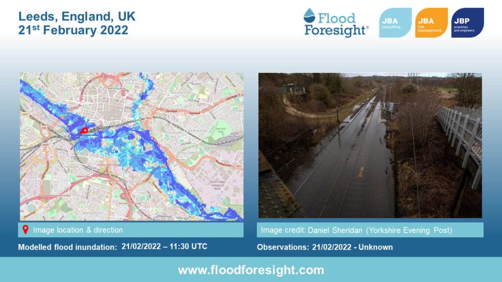
Much of the city of Leeds was flooded which caused widespread traffic congestion, and rail lines were also flooded. Due to the high and fast flowing-water level in the River Aire, a pontoon from the Leeds Flood Alleviation Scheme was carried downstream, destroying a footbridge.
Our Flood Foresight Fluvial forecasting system forecasted flooding six days in advance of the actual flood events. And the Flood Foresight monitoring system modelled the flood inundation footprint for the River Aire at Leeds on 21 February. The image below shows the Flood Foresight flood inundation map and a photograph of actual events on the ground.
Sources:
Brown, M., Topham, G. & Campbell, L. (2022) Storm Franklin: ‘danger to life’ flood warnings in Shropshire and Worcestershire. The Guardian, 21 February 2022. Available online: https://www.theguardian.com/uk-news/2022/feb/21/storm-frankin-hundreds-evacuated-and-travel-halted-uk [Accessed: 14.03.2022].
Gov.uk (2022) Flood Alerts & Warnings. Available online: https://check-for-flooding.service.gov.uk/alerts-and-warnings [Accessed: 21.03.2022].
Flood Foresight is a globally-scalable operational system providing data on rainfall severity, flood inundation footprints and depth, and flood impacts. Contact John Bevington for more information about Flood Foresight or visit our Flood Foresight webpage and download our Executive Summary.
Services
Delivering transformative technology that is pioneering in the pursuit of flood, water and environmental resilience.
Developing leading resilience strategies and solutions founded on the integrated modelling and assessment of water quantity, quality and environmental processes.
Working within a robust and mature digital delivery environment, our engineering specialists work closely with our modelling, hydrology and environmental teams to ensure designs are developed to create efficient, low-carbon and sustainable solutions.
Our specialists in landscape, heritage, ecology, fisheries, EIA, planning and sustainability all work collaboratively with our engineering designers, modellers and our project managers to develop resilient places.
Our proven skills and experience make us a natural partner to help support communities and organisations to become more resilient. We support and empower our clients to manage the twin risks of flood and drought, encouraging and delivering effective water management.
Working with communities across the world to identify and mitigate flood and environmental risks, support sustainable development and build resilience.

